Mobility mapping
Working with our community to provide accessible places and a range of options for travelling across the Sunshine Coast.
Council recognises that creating an accessible city is a key factor in improving the lives of residents and visitors.
Council is committed to working with our community in providing accessible places and a range of options for travelling across the Sunshine Coast.
Mobility mapping Sunshine Coast
Council has partnered with Briometrix to undertake the mobility mapping project which is focused on inclusivity and mobility, changing the way our community travels across popular areas of the Sunshine Coast.
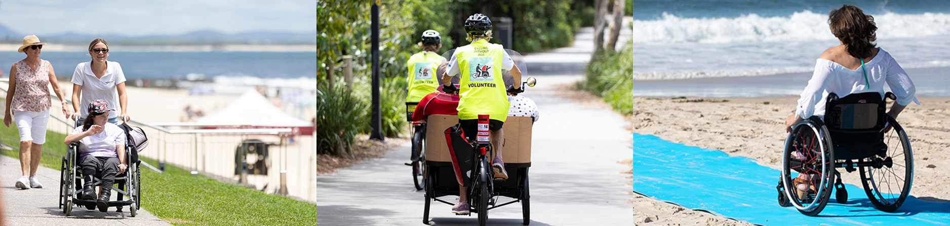
Using modern mapping technology, wheelchairs and ebikes are turned into mapping tools with specially trained ‘pilots’ and devices installed to track routes from Coolum to Caloundra.
We are mapping how easy - or difficult - it is for those in wheelchairs, pushing prams, using mobility aids or with vision impairment, to get around particular areas.
The information will help inform footpath refurbishment and upgrades to improve accessibility.
This project has become a nationally recognised award winning project, for connecting community through infrastructure.
The areas mapped to date are Alexandra Headland, Beerwah, Birtinya (Sunshine Coast University Hospital and Kawana Stadium), Buddina, Caloundra, Coolum, Cotton Tree, Currimundi, Kawana, Maleny, Maroochydore, Montville, Mooloolaba, and Nambour.
The mobility maps identify footpaths, shared pathways, and trails accessible for people of all abilities, from mums and dads with toddlers in tow to the elderly with walkers, people using mobility aids, and anyone with wheels on pathways.
The paths are graded by the effort required to travel the pathway by an average wheelchair pilot.
*Effort is based on the slope of the path, the surface condition, and the cross slope of the footpath.
Open the Sunshine Coast Mobility Map to find your best path, given your needs and ability.
*Effort ratings are a guide and may vary depending on the physical condition of the wheelchair pilot, and any power assistance available.
Path conditions may change without notice.
See More information (below) for advice on how to optimise your use of the maps.
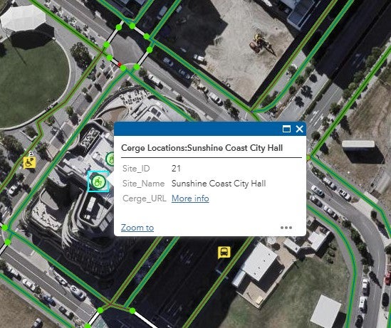
Cérge
Complementing the mobility maps, Council has also joined forced with local technology company Cérge, to improve access and inclusion for Council spaces that showcase arts, entertainment, environmental activities, sport, and recreation.
A series of accessible tools have been developed so people can "know before they go" and understand venue accessibility ahead of time.
These can include a 360-degree Virtual Tour, Visual Story and Sensory Guide and Audio Guide.
Cérge can be accessed by clicking on the icon within the mobility maps. This will provide a link to the Cérge information for that venue or facility, for example:
National Public Toilet Map
The National Public Toilet Map shows the location of more than 23,000 public and private public facilities across Australia, including toilets, adult change and baby care.
Information is provided about each toilet, such as location, accessibility details, opening hours and features like sharps disposal and showers. You can view the National Public Toilet Map here.
The Toilet Map is funded by the Australian Government Department of Health and Aged Care as part of the National Continence Program and is managed through the Continence Health Australia.
More information
Download more information about the Mobility Maps.
Access the Council User Guide. For web-based Briometrix Mobility Maps, access the User Guide.
Find out more about Council's Accessible Beach Program in the mapped area.
Find a range of options for travelling across the Sunshine Coast on council’s Transport and mobility page.
Accessible Australia web app is a free online resource that gives you the ability to know what services and infrastructure are available at a destination before you visit.
Watch the video to see how the pilots used innovative technology to collect information about our footpaths, public transport and parking, amenities, boardwalks, beach accesses and more.
Media releases
- Wheels in motion for inclusive-mapping pilot project (February 2022)
- Your accessible Sunshine Coast (April 2022)
- Wheelie great cause all in a days work for Council
- Project wins national accolade
- 2022 Productivity through infrastructure award
Contacts
For more information, please contact council.