Mountain Bike Track IoT monitoring service
This monitoring project focuses on understanding the use and management of the popular mountain bike trails.
Council is using real-time and historical data insights that identify areas of high use that may require priority maintenance, and monitor environmental impacts caused by heavy rainfall.
| Category | Bringing data to life |
| Location | Sugar Bag Rd, Caloundra West |
| Project status | Operational |
| Start date | 1 July 2022 |
| Completion date | Ongoing |
| Cost | $21,100 |
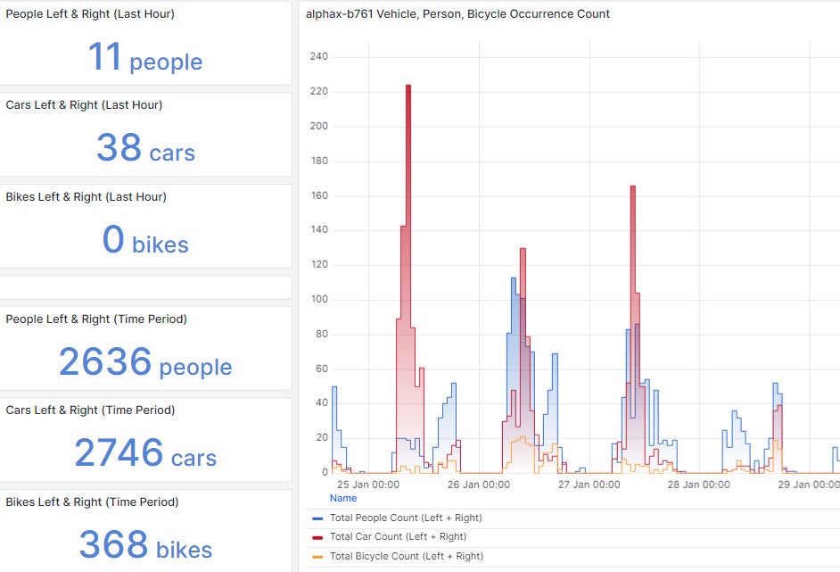
Examination of use patterns and trends can also determine popular areas for facility improvement and potential expansion. The below image shows a snapshot of the count of people, vehicles and bicycles near the entrance of Sugar Bag Road Recreation Reserve.
Challenge
Challenge
The Mountain Bike Track is a popular riding location for locals and visitors.
Increasing visitor numbers have significantly impacted wear and tear of the bike tracks, including track erosion due to heavy rainfall. Ongoing maintenance and operational requirements add increasing pressure to already tight council budgets.
Solution
Solution
Several Internet of Things (IoT) sensors are located at strategic points across the Mountain Bike Track park and trails:
- 1 x weather station – Provides real-time information about temperature, humidity, wind speed, rainfall and solar irradiance.
- 1 x WiFi probe counter - counts the number of connected devices in the carpark area, including dwell time.
- 3 x object detection cameras - count and categorise the number of people, vehicles and bikes in the carpark, at a major track entrance and café area. No private information is captured by these cameras.
- 4 x passive infrared bi-directional counters - use heat signature to identify people passing along the tracks, plus their direction of movement.
- 5 x passive infrared counters – count the number of people entering and exiting at two amenities facilities and three additional trails.
- 2 x vibration counters - Counts the number of bikes crossing over two trail challenges.
- Data from all sensors is aggregated via a LoRaWAN IoT gateway, which provides a network service.
- The data is presented on a live dashboard that provides easy access to council staff who can view near real-time and historical trends.
- Maintenance alerts are sent to allocated staff when a sensor or device is offline or has a low battery voltage.
Outcomes
Outcomes
The project uses an end-to-end IoT solution that provides low-cost entry and high scale deployment of multiple sensors within typical budget constraints, and can be replicated across council branches.
This enables significant costs savings compared to 3-5 years ago when individual branches sourced separate, expensive IoT components, often from different vendors.
Where council previously deployed individual sensors in a location using one or two technologies, the Mountain Bike Track IoT project uses a combination of human movement counting and categorisation sensors plus a weather station that captures a range of environmental data.
These multiple sensors count how many people visit the site each day, how many of them use the bike track challenges and amenities, plus the number of vehicles in the carpark. The data shows a high correlation between the number of vehicles and visitors at the site, and the high use of the amenities.
These combined data sets provide an integrated perspective that support council’s maintenance schedules and additional funding requests.
This project has resulted in additional operational budget and capital works funding for embellishments as the data reflects higher visitor uses that initially expected.
The success of this project demonstrates council’s step towards becoming a data driven organisation that responds and plan more efficient services and facilities, rather than using anecdotal information to understand how people are using the region.
As a result, IoT monitoring programs have been implemented at two additional sites:
- Mary Cairncross Scenic Reserve, a 55ha subtropical rainforest in Maleny: Sensors capture people movement to enable efficient visitor management, plus environment data such as temperature, weather conditions, and soil moisture to help understand the effects of seasonal and climate changes on plants and wildlife.
- Maroochy Wetlands Sanctuary: Sensors capture environmental data relating to water quality, air temperature, humidity, and wildlife activity to provide valuable insights into the site’s ecological health.
Future uses
Future uses
Evidence-based data can help inform dynamic budgeting based on higher use impacts, such as scheduled events and heavy rainfall, with less funds allocated during quieter months.
This data could also inform state and federal grant applications for capital works projects, which increasingly require evidence-based information to support the funding requests.
Awards
- 2024 Queensland iAwards winner for the government and public sector category
- 2024 Australian IoT Awards finalist for the remote monitoring category
More information
Email [email protected].