Flooding questions and factsheets
Find out more about council flood mapping and information with our frequently asked questions, fact sheets and more.
Council provides a range of flood mapping products and information to enable the community and industry professionals to make informed decisions for emergency preparedness and land use planning purposes.
Factsheets
- Emergency preparedness flood maps (PDF, 1811KB)
- Land use planning flood maps (PDF, 1851KB).
Why does council update flood mapping?
Council updates flood mapping and flood information to ensure the community has access to the most up to date, detailed information. It enables residents to make informed decisions and builds the region’s resilience.
The flood mapping and information respond to the Queensland Flood Commission of Inquiry’s recommendation that local governments provide risk-based mapping so residents, professionals and local government can more clearly understand, prepare for and manage flood risk.
Council is planning ahead for future challenges such as increased rainfall intensity and permanent sea level rises, to help respond to flooding. We’re taking action now to help manage the risk of the impacts of climate change and severe weather events.
Through this mapping, council is providing information which helps landowners and users understand the flood risk which exists on a property.
The flood mapping and information does not create more risk on a property. They simply provide more detailed information for a property owner to understand existing risk.
What are the benefits of up-to-date flood mapping and information?
Access to up-to-date flood information enables our community and industry professionals to make informed decisions for a wide range of activities including:
- emergency preparedness
- education and insurance
- land use management and planning
- infrastructure
- building controls
- coastal management
- structural works
- landscape and environment.
Emergency preparedness
Up to date flood information helps you understand how flooding and overland flow may affect aspects of your everyday life at home, at work, at school or on the road. Understanding and acting on this information helps build strong and resilient communities.
Making property changes
Up to date flood information helps industry professionals delivering and planning development or building works understand how flooding and overland flow may challenge development or building works and design solutions to avoid or work around these challenges.
Ultimately this is in the best interest of the people who will live in these buildings. Smart design avoids or mitigates the risks of flooding to people and property and helps to manage the consequences of flooding and promotes affordable insurance.
What flood maps and information are available?
Council has a range of flood mapping products. Some of the products will only be visible when zoomed into a particular site. The flood mapping products can be divided into two categories:
- emergency preparedness flood mapping, and
- land use planning flood mapping.
Emergency preparedness flood maps consider a range of events (minor, moderate, major and extreme) and includes:
- regional creek and river flooding
- overland flow flooding (including a highlight of areas that may be inundated for extended periods during local storm events)
- storm tide.
Land use planning flood maps consider:
- flood risk
- stormwater risk
- defined flood event (including overland flow)
- flood storage preservation area
- flood hazard area for building regulation purposes.
Why has council adopted a map outside of the planning scheme, specifically for building regulation purposes?
The Building Act 1975 and the Building Regulations 2021 requires council to declare a flood hazard area for building regulation purposes.
Historically, the planning scheme flood hazard overlay map was used for this purpose.
However, council has adopted a dedicated flood hazard area for building regulation purposes map.
This map identifies additional buffer areas that are relevant to building works, and account for overland flow paths, drainage and freeboard.
Adopting the map outside of the planning scheme enables the mapping to be regularly updated as more information becomes available.
It also ensures that building certifiers can continue to easily:
- identify properties that are not mapped as flood affected but are adjacent to flooding so this can be considered when setting floor levels
- consider flooding associated with stormwater drainage
- understand the location of overland flow paths.
The absence of flood mapping does not imply that a property is not subject to localised stormwater flooding or drainage issues. The National Construction Code (Volume 2) requirements for the management of surface water remain applicable outside of the flood hazard area for building regulation purposes map.
Why is my property included in the flood risk mapping area?
What does that mean?
Council is providing information which helps all landowners and residents on the Sunshine Coast understand the possible impacts of flood on a property and make plans to build their resilience.
Properties across all zonings are included in the flood risk map including residential, commercial, industry, rural residential and rural land use zonings.
If your property is included in the flood risk map it means there is an existing risk - low, moderate or high - of flood.
You can also use the emergency preparedness mapping to think about how your property might be affected by different sized flood events, and any changes you may need to make to build resilience and prepare for flooding.
What do the flood risk ratings mean?
Depending on your location, you may experience floods differently. Your location will determine whether you are likely to experience river, creek, overland flow, storm tide flooding or a combination of several of these types of flood risks.
Flood risk is made up of many pieces of information which help us understand:
- flood likelihood - how likely a flood is to occur (bigger floods are rarer, smaller floods more common)
- flood hazard - how dangerous the flood water is, which depends on how deep the water is and how fast it is flowing.
Flood likelihood and flood hazard are considered in each geographic area to arrive at a risk rating.
Risk rating definitions
High risk - these areas present a high and unacceptable flood risk to life and property.
Moderate risk - flood risk does not meet contemporary standards. However, it is expected that the urban renewal of coastal lots, over time, will deliver an acceptable risk outcome.
Low risk - flood risk is low and meets contemporary community standards. If it becomes possible to reduce this risk at either an individual or community level, it is recommended that the opportunity to do so is given consideration.
Recent development area - flood risk is not mapped as the area has recently been developed. This is likely to have changed the flood risk. Site specific flood studies for the development may be available on Development.i.
Other areas of the floodplain - these areas present a very low risk to life and property.
What do the stormwater risk ratings mean?
Like flood risk, stormwater risk is also made up of many pieces of information which help us understand:
- event likelihood - how likely a stormwater flood event is to occur (bigger events are rarer, smaller events are more common)
- event hazard - how dangerous the stormwater runoff is, which depends on how deep the water is and how fast it is flowing.
The likelihood and hazard of a stormwater flood event are considered in each geographic area to arrive at a risk rating. Detailed stormwater risk mapping is not available for all areas.
Areas can be subject to both flood risk and stormwater risk as multiple mechanisms of flooding can occur. Filling to reduce flood risk should not occur if this conflicts with the stormwater function of that area, e.g. it prevents surrounding properties from being able to freely drain. Stormwater risks should be managed to reduce the potential for damage and nuisance.
High stormwater risk - areas subject to concentrated overland flow that can be deep and/or fast flowing in frequent rainfall events. These flow paths form part of the local stormwater network as they convey stormwater runoff and provide drainage relief. These flow paths should be protected. Property or obstructions to flow (e.g. solid fences) should avoid being located in these areas.
Moderate stormwater risk - areas subject to concentrated overland flow that can be deep and/or fast flowing in heavy rainfall events. These flow paths are important for the drainage of surrounding areas. Development within these areas should avoid or manage the stormwater risk. The stormwater function of these areas should be maintained to prevent nuisance drainage issues and stormwater damage to property.
Low stormwater risk - areas subject to overland flow that can be deep and/or fast flowing in extreme rainfall events or if there is blockage of the stormwater network. These areas can also provide important drainage flow paths for surrounding areas. Development within these areas should manage these stormwater risks. The stormwater function of these areas should be maintained to prevent nuisance drainage issues and stormwater damage to property.
Lower stormwater risk - areas subject to overland flow that can be moderately deep and/or fast flowing in extreme rainfall events or if there is blockage of the stormwater network. These areas can also provide important drainage flow paths for surrounding areas. Development within these areas should consider these stormwater risks. The stormwater function of these areas should be maintained to prevent nuisance drainage issues and stormwater damage to property.
All other areas - all surface areas create stormwater runoff, not just areas that are mapped as having a stormwater risk. The management of this runoff needs to be considered as part of development in order to prevent nuisance drainage issues and stormwater damage to property.
Methods of managing stormwater risks can be very specific to a property and what is being proposed. Due to the complexity of some sites, in some situations the services of a Registered Professional Engineer of Queensland (RPEQ) may be required to manage stormwater risks.
What is flooding, stormwater and overland flow?
Flooding is defined as the covering of normally dry land by water that has escaped or been released from the normal confines of any lake, river, creek or other natural watercourse, whether or not altered or modified; or any reservoir, canal, or dam. (Insurance Council of Australia).
Stormwater is rainwater that has not yet entered a watercourse or soaked into the ground. Stormwater is managed to ensure that stormwater flows cause minimal nuisance, danger and damage to people, property and the environment.
Overland flow is stormwater runoff that flows across land before it enters a watercourse or the stormwater network. Overland flow can also occur if the stormwater infrastructure is blocked or has exceeded its capacity.
Flooding can be associated with stormwater when the movement of stormwater over land becomes concentrated and deeper, prior to entering a watercourse.
If you have any further questions about this information, please reach out to our team at [email protected].
Flooding can occur after heavy or prolonged rainfall.
Overland flow occurs as the immediate surface runoff response from rainfall on a local area.
Overland flow is often associated with short-term flooding of roads and urban areas. Roads are important overland flow paths and are designed to convey water that exceeds the capacity of underground stormwater drainage infrastructure. Overland flow can also occur through private properties. Property owners are required to accept natural overland flow from adjoining properties, public land and roads.
River and creek flooding involves water rising or flowing onto adjacent land that is normally dry.
Storm tide flooding is another flooding source that involves water rising onto adjacent land that is normally dry. These mechanisms of flooding are shown in the figures above.
Is overland flow path and stormwater risk mapping available everywhere?
Detailed overland flow path and stormwater risk mapping has been developed for most urban areas and will be expanded to include all urban areas over time.
Should I purchase a flood information search?
If you are undertaking building works within the flood hazard area for building regulation purposes map of the Sunshine Coast planning scheme, you will need to get a flood information search. This provides property specific flood level, building floor level and velocity information required by MP 3.5 Construction of Buildings in Flood Hazard Areas.
For simple situations where a flood information search can be automated, the flood search information is provided on the Development.i Site report, tabulated under the flood hazard area for building regulation purposes map.
For complex situations where the flood search is unable to be automated, a manually created flood information search will be required. This is provided as a paid service that produces a customised flood report for a specific property.
If you simply want to be well informed about whether a property is affected by flooding and you are not undertaking building works, please refer to council’s land use planning and emergency preparedness flood mapping.
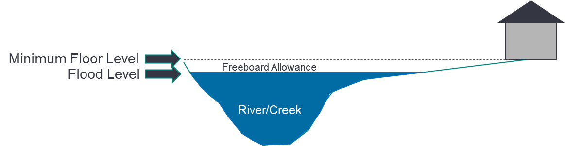
Why is the freeboard allowance used when setting minimum floor levels?
The freeboard allowance addresses any uncertainties in our flood level estimations that are used to specify appropriate floor level immunity. It also accounts for unforeseeable circumstances that may occur in a real flood event, which differs from the flood model’s assumptions. For example, this could be something like blocked stormwater pipes, highly turbulent flow or a fallen tree blocking water flow.
Freeboard allowances differ depending on the source of flooding. River and creek floods typically have a 500mm freeboard applied. Stormwater flooding associated with drainage has 300mm of freeboard.
Some properties will have multiple sources of flooding. The flood level and freeboard requirements which results in the highest minimum floor level will need to be used for each property.
Why hasn’t my flood information search been able to define a minimum floor level?
Some properties will not be able to have a minimum floor level defined in the flood information search obtained from council. This can be due to a number of reasons, such as surface levels and flood levels being variable or the lot being located below the road or flow path.
The flood information search will provide further details of what should be considered for each property. Further site specific information may be able to be obtained if a building plan is submitted with the flood search application, or emailed to [email protected].
Local site drainage also needs to be considered when setting minimum floor levels. A building certifier should ensure that minimum floor levels also meet the requirements of the National Construction Code and that all internal stormwater drainage complies with Australian Standard AS/NZS 3500.3 – Plumbing and Drainage.
Why are the overland flow path and flood extents the same on my property?
Detailed overland flow path modelling has been used in urban areas to define stormwater risk for properties. In some locations the contributing catchment area or flow characteristics have become significant enough that it has been classified as flooding. This means that additional freeboard will be required when setting minimum floor levels. As the same model has been used, the extents will be the same in both mapping layers.
Some properties will have multiple types of flooding, and it can also be difficult in some locations to differentiate, particularly for region wide mapping, where overland flow becomes flooding. The overland flow path and stormwater risk mapping have been provided in addition to the flood risk mapping to ensure that all stormwater and flooding risks are appropriately managed on each property.
I’m buying a property. What flood information is available to inform my decision?
Our land use planning, flood risk maps provide information about the existing - low, moderate or high - flood risk on a property.
The stormwater risk maps also provide information about the existing stormwater risks – low, moderate or high – on a property.
Our emergency preparedness maps provide additional information about how a property might be affected by different sized flood events. Take note of the minor and moderate flood events as they occur more often.
Council encourages the community to familiarise themselves with all our flood mapping and information.
Think about any changes you may need to make to build resilience and prepare for flooding.
The flood mapping shows my property as flooded, which I agree with, but my house is up high and has never flooded. Why does the mapping show my house as flooded?
Flood models use a product called Light Detection and Ranging (LiDAR) to survey ground level information from a plane. This product is also referred to as Aerial Laser Survey (ALS). The ALS product used in flood models removes some information, such as buildings, trees and bridges. Therefore, the flood model and flood mapping ignore buildings and for this reason they can sometimes be shown as flooded.
The flood mapping shows the natural path of water if obstructions such as buildings or solid fences were not in place.
Excluding buildings entirely from flood modelling and mapping is not recommended as this may erroneously show low set buildings as not being at risk of being flooded.
The flood mapping shows my property floods, but I have never seen it happen. Could the flood mapping be wrong?
There are a number of flood maps. The defined flood event includes climate change allowances which are yet to be fully realised. Council also provides flood mapping that has different flood likelihoods. When looking at mapping of major or extreme floods the likelihoods have a very small chance of occurring, in a given year, and there is a good chance that you have not lived at the location long enough to observe a major or extreme flood.
The chance of experiencing flooding at your property increases the longer you live at a given location, but there is still only a 50% chance you will see a major flood if you live at that location for 70 years.
You are much more likely to have experienced minor or moderate flooding, so it is recommended that you also check these flood event levels, when reviewing flood mapping at your property.
Council mapping may also show overland flow paths on your property. This type of flooding can be shallow, and you may not even consider it flooding. It is often only visible for a short time and you may not be at the property or awake to observe it.
For example, overland flow can occur when water runs quickly off a hillside after rain, or when the stormwater network is draining slowly following storm events.
If I think council’s flood mapping is wrong, what can I do?
Council’s flood models are developed through a very thorough process using observed data to calibrate the flood model and validate results. Changes to council’s flood mapping must be evidence based, for example, when new data becomes available following a master drainage study.
Council’s flood models use Aerial Laser Survey (ALS) data and details of the stormwater network. Changes to surface levels and the stormwater network will be incorporated into periodic model updates. It is not feasible for council to update modelling and mapping with every change. Recent changes within your property may have altered overland flow and flooding behaviour from that shown on council’s mapping.
If you have concerns about the flood mapping on your property, you can get in touch with council’s flooding and stormwater team who can discuss the mapping information with you. Email [email protected].
Does council provide its flood mapping to insurance companies?
Council provides its flood mapping to the Insurance Council of Australia, to ensure that insurance companies have access to reliable flood information.
When insurance companies have access to this information, they are able to confidently set informed insurance premiums.
This promotes competition in the insurance market and competitive pricing generally results in insurance premiums being more affordable.
Will council’s flood mapping impact my insurance?
While flood information can inform insurance premiums, it is vital the community has the information it needs to determine any flood risk that may exist for a property and make plans to manage that risk for themselves and their families. It also means that future development can account for flood and stormwater risks, so that future damages can be avoided and the cost of insurance across the region will be reduced.
The insurance industry uses a range of information to make decisions around property insurance premiums. Insurance premium prices are based on the individual site. Detailed flood mapping can have a positive impact on insurance for some people as it provides more specific information about a property’s flood risk and allows for more accurate pricing.
If you are concerned that your insurer may not be accurately accounting for flooding on your property, we encourage you to:
- check council’s emergency preparedness mapping
- seek quotes from at least two other insurance companies
- provide your insurer with information about how flooding and stormwater risks have been managed on your property (e.g. raised buildings which allow flow to pass underneath).
If you have made improvements to increase the flood resilience of your property some insurers may take this into account if they are provided with sufficient evidence.
Does flood mapping affect my property values?
Flooding is one of many factors which can affect the value of a property, however council is unable to advise how flood mapping may impact property values.
Up-to-date public flood mapping and information is provided in response to the 2012 Queensland Floods Commission of Inquiry’s recommendation that local governments provide risk-based mapping so residents, professionals and local government can more clearly know, prepare for and manage flood risk.
Will the new mapping stop me from undertaking works/developing my property?
The flood hazard area for building regulation purposes mapping is relevant to building works, or property development.
Council’s other mapping products may be considered as part of the new Sunshine Coast planning scheme project which is underway and may be relevant to development in the future. But this is currently not the case.
The new mapping provides more detailed information about a property’s existing flood risk. Council strongly urges anyone seeking to develop, to understand the flood and stormwater risks that affect their property.
Considering how a property is affected by flooding and overland flow early in the planning phase helps ensure design solutions are identified to avoid or work around flooding, overland flow and stormwater drainage challenges. This helps build strong and resilient communities.
It also avoids potential problems like rectification works needing to occur after construction, or legal disputes between neighbours if an overland flow path becomes blocked.
What is a flood model and how do council’s flood models work?
A flood model is a numerical computer-based model used to create flood mapping. Flood models estimate flood levels from rainfall information sourced from the Bureau of Meteorology (BoM).
Some of our flood models consider how rainfall is converted to flow. These models are called hydrology or hydrologic models.
Other council flood models convert flow to a water level. These flood models are called hydraulic models.
Generally, our regional flood models use a hydrology model first to calculate flow in smaller areas of each catchment.
These flows are then applied to the hydraulic model.
Generally, our local area models only use a hydraulic model, but in these models a “rain on cell” technique is also used.
This means that rainfall is put onto every cell in the model. The model then figures out how the rainfall runs over the land and into the stormwater network. This type of modelling is more sophisticated, and it takes longer to run the model.
Who develops a flood model?
Industry experts have been engaged to assist with developing council’s regional flood models. These models were then peer reviewed by other industry experts to ensure the models were developed appropriately.
The local master drainage plan models were developed by external consultants. Council has also developed its own overland flow models.
What is a flood study?
A flood study is a comprehensive technical investigation of flood behaviour in a particular area.
It defines the nature and extent of flood hazards in the study area by providing data on the extent, depth and speed of floodwaters. The flood study can also contain detailed reports and maps to show inundation extent, depth, velocity and hazard for events of various likelihoods.
Does council consider climate change in its flood studies?
Yes, generally all flood studies include allowances for climate change.
These include a 0.8m sea level rise increase at the ocean boundary of the flood model and a 20 per cent increase in rainfall intensity, as required by the state government and recommended by the Intergovernmental Panel on Climate Change.
What type of flood models does council use?
Council has the following types of flood models:
- regional flood models for our five main river catchments (Mary, Mooloolah, Maroochy, Pumicestone, Stanley). These models deal with water rising in creeks and rivers
- local area flood models for drainage investigations, and overland flow path models. These models deal with rainfall runoff that flows overland and through the stormwater network.
Does council follow the same process for flood modelling as other councils in Australia?
Generally, yes. Flood models are developed following the guidance of Australian rainfall and runoff, Queensland urban drainage manual and the guide for flood studies and mapping in Queensland. Rainfall intensity/depth data is sourced from the Bureau of Meteorology (BoM).
Sunshine Coast Council uses a slightly different temporal pattern for the distribution of rainfall over time than other councils when determining design flood levels.
This temporal pattern is called the duration independent storm. It is a synthetic temporal pattern with a central peak and incorporates the rainfall depths for each sub-duration provided by BoM (for each rainfall probability).
Council has observed that it is necessary to use this temporal pattern because it provides good agreement with the levels and probabilities of observed historic floods.
What is a defined flood event map?
The defined flood event map represents a flooding and storm tide event with one per cent chance of occurring each year. The map is also based on planning horizons set at the year 2100. As such, the mapping makes allowance for climate change which includes 0.8m sea level rise and 20 per cent increase in rainfall intensity.
Data from the defined flood event map is used to inform floor levels and flood immunity requirements for development and infrastructure. A flood information search provides a property specific flood level and minimum floor level based on defined flood event mapping, so that building works or infrastructure can achieve the required flood immunity.
What is a 100-year flood?
A 100-year flood is a flood that will occur (or be exceeded) on average once every 100 years. However, it is possible that the flood could occur more than once in a 100-year period, or that it will not occur at all. The Queensland Floods Commission of Inquiry recommended referring to this flood as the one per cent flood to avoid people thinking this event would only occur once every 100 years.
For emergency preparedness purposes, the 100-year flood is labelled as the major flood level on council’s Disaster Hub flood mapping.
The 100-year flood has traditionally been used for land use planning and informs the minimum floor level for homes. There is also an extra allowance called freeboard, which ensures the floor level is certain to be above the 100-year flood level.
Are there larger design floods that could be shown in the mapping?
The flood risk map considers floods across a broad range of flood event likelihoods. This includes the Probable Maximum Flood (PMF). This is the largest flood that is theoretically possible using reasonable worst-case assumptions for estimation. Some manuals use this flood to define the extent of the floodplain.
The various flood mapping products council provides will sit well within the extent of the PMF, which is labelled on the Flood Risk map as other areas of the floodplain.
How do I find out about flooding during a flood event?
As part of our flood warning system, council operates and maintains a network of gauges to inform the Local Disaster Coordination Centre.
Many of the gauges are operated in tandem with the Bureau of Meteorology.
This information is publicly available via Disaster Hub. The following, near real-time information, is collected as part of the flood warning system:
- water level gauges
- rainfall summary
- flooded road (unverified).
This information is provided to empower the community during heavy rainfall and flooding events. The information is also useful for flood emergency management planning.
What action, if any, do I need to take?
Council encourages the community and industry professionals to familiarise themselves with the updated flood mapping and information.
As storm season approaches, it’s a good time to go online and check your property using our emergency preparedness flood mapping.
Residents are encouraged to look at locations where they live, where they work, or where their friends and family may go to school and look at how flooding affects the routes they often travel. It’s important to have a backup plan or know what alternative routes you could take.
If you are making changes to your property such as major building or renovations, ask your planning professional to check your property using our land use planning flood mapping to determine if a flood information search is required.
The new flood information may also be relevant to a site you wish to develop. It could provide insights about flooding characteristics outside, but surrounding, your site. This is particularly relevant when planning evacuation routes or considering the need for a safe refuge on site, in the event there is risk to life due to flooding.
Think about how your property might be affected by different flood events or flood mapping products and any changes you might need to make to prepare for flooding now or in the future to increase your own resilience.