Maroochydore nearshore beach nourishment trial
Council ran a trial to manage erosion on Maroochydore Beach.
We’re being proactive and exploring other ways to manage our beaches from the risk of coastal erosion in the future. As well as local sand renourishment pumping, nearshore sand nourishment is another method we could use to do this. This trials results have helped us understand how effective the technique is at Maroochydore.
Project scope
Studies show that there is a limited supply of sand on the Sunshine Coast. Maroochydore beach has been subject to significant erosion events and the addition of new sand from an external source will help to restore sand to the beach and protect the area from erosion.
Nearshore sand nourishment is one method available to help do this. It works by taking sand from another source in the coastal system, such as the spitfire channel, and placing it in the nearshore area off Maroochydore beach.
The nearshore nourishment trial provided evidence to support our understanding of the operational aspects of delivering additional sand to the Sunshine Coast using this sand nourishment method. It also helped us to optimise the ‘value for money’ considerations if we were to use this type of coastal management practice along our coastline in the future.
A technical advisory group was established to highlight any technical issues or concerns that may arise during the trial. Councillors, Queensland Government, Sunshine Coast Council, Surf Lifesaving Queensland, Queensland Police Service and expert engineering consultants were part of the group.
Watch this YouTube video to find out more about council's nearshore beach nourishment trial.
Project update
The nearshore nourishment campaign went ahead in November 2022. The dredge worked 7 days a week, 24 hours per day. Sand placement took place approximately every seven hours about 300m offshore between BA151 – BA155. Please see the placement map (PDF, 410KB) for details.
Project details
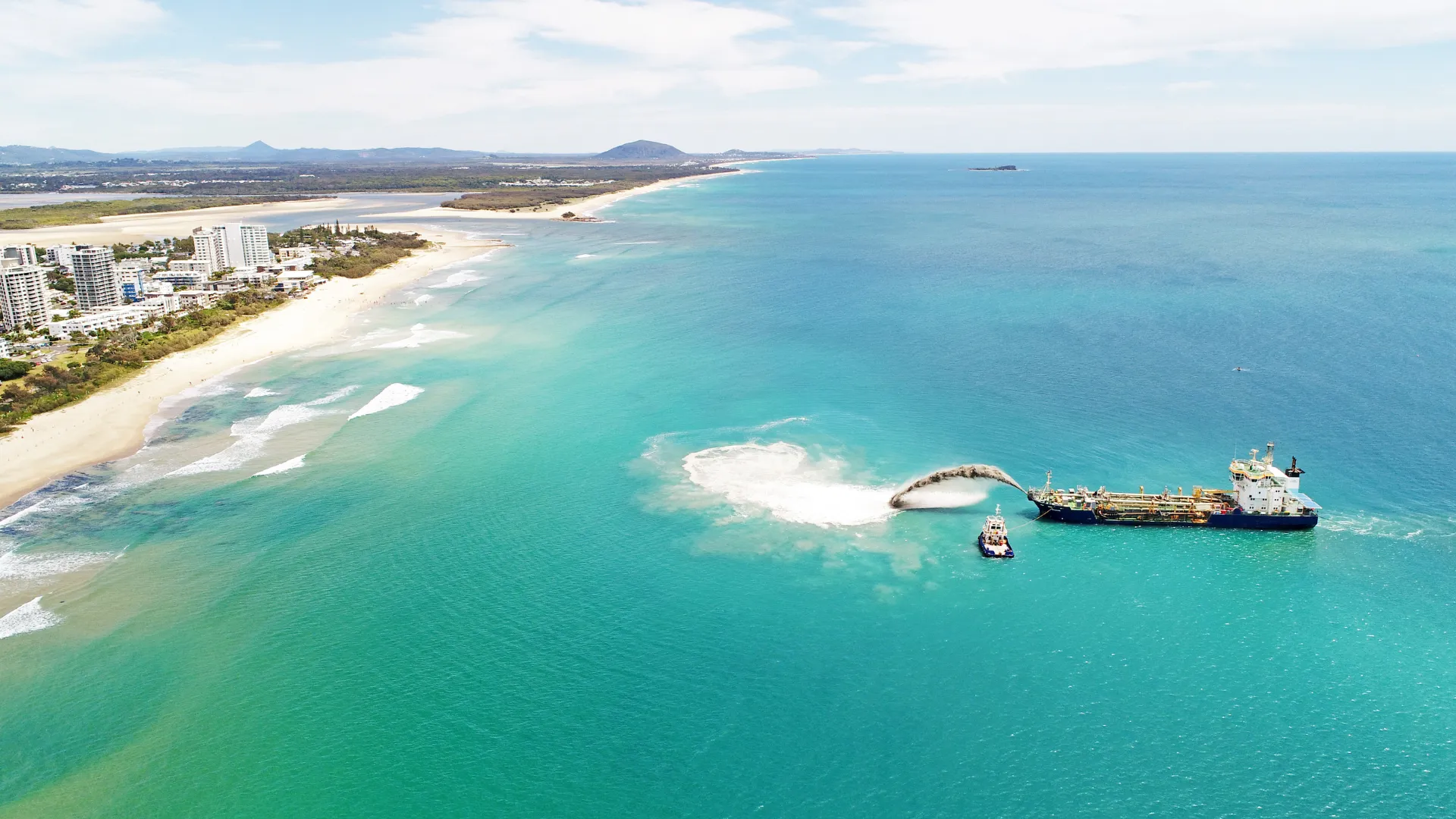
The trial was carried out with a trailing suction hopper dredge, which is a certified ocean-going vessel. It can dredge in depth of 25m and can carry (has a hopper capacity of) 2,900m3, which is the equivalent of hundreds of trucks of sand being released with each load.
The dredge came from the Port of Brisbane. The Port of Brisbane Pty Ltd’s Marine Services teams is responsible for safe navigation of the 90km shipping channel. Dredging forms part of these operations and the Port of Brisbane owns a flagship vessel, the TSHD Brisbane, which was used for the nearshore sand nourishment work at Maroochydore.
The dredge took sand from the shipping channel and placed it in its hopper or hull. The sand was released at Maroochydore via “bottom placement” and rainbowing.
Bottom placement operation involved opening the doors at the bottom of the dredge hull above the position required and allowing the sand in the dredge hopper to fall onto the seabed below. Rainbowing involved spraying a sand and water slurry from the deck of the dredge into the nearshore zone.
The sand was placed in a formation to encourage sand migration towards the exposed beach, respectful of the site surf amenity.
The dredge worked for 24hours a day. It took around seven hours to complete a full cycle which involved taking sand from the navigation channel in Moreton Bay, steaming to Maroochydore, placing the sand offshore from the beach, and then steaming back to the navigational channel.
Approximately 40,000 cubic metres of sand was used for the trial.
Nearshore nourishment trial outcome summary
Following a review of the data, we have concluded that it did produce an increase in sand on the Maroochydore beach.
The technique could potentially be used on a larger scale for future nourishment campaigns along Maroochydore Beach and in other coastal locations.
A summary of the findings is below or for more information please read the expert consultants final report (PDF, 10.49MB).
Beach surveys: hydrographic surveys and cameras monitored sand movement since the trial finished. Monthly topographic (upper beach) survey results show there was a net increase of 34,170m3 of sand in the upper beach profile along Maroochydore Beach from December 2022 to April 2023.
Surf amenity: a study via UniSC has closely watched the impacts to surf amenity and the results were inconclusive - neither positive nor negative.
Reef impacts: more will be known about any possible impacts on marine plans and the reef when divers complete their next marine plant survey in November 2023 (as per the permit conditions 2201-27063 SDA).
Safety: safety measures were appropriate for the scale of works (closing of the beach and water), no incidents or near misses occurred during the operational phase of the trial.
Location: using Maroochydore beach for this project provided an opportunity to test the technique in a more challenging environment. Maroochydore beach was also chosen due to a lack of sand. Maroochydore beach was a challenging beach to undertake the trial at as it is not a linear beach. It is an embankment with rocky headlands and rivers at its boundaries. Sand nourishment using nearshore nourishment is hard to model along this beach – which is why a trial was needed.
Straight stretches of beaches (Kawana – Moffat, Yaroomba – Maroochy Northshore) are a simpler setting to model and this technique will have a high likelihood of success if used at these types of locations.
Community sentiment: The small number of responses suggests that the majority of the community did not have major concerns with the project. Council confirmed that there were no customer requests created during the operational phase of the project, suggesting that beach closures were generally accepted.
Considerations for future campaigns
- placement of sand to use the rainbow technique first and then place the sand via bottom placement behind the rainbowing to ensure sand is placed closer to the shoreline to allow it to migrate efficiently into the upper beach
- the location of nourishment was appropriate and the buffer to the reef habitat should not be reduced to ensure no lasting impacts on reef habitats as a small portion of sand migrated south during the monitoring period
- extend the surf amenity survey for any future campaigns and include baseline data (pre-surf condition assessment)
- cost efficiencies would improve if sand could be sourced closer to Sunshine Coast (directly offshore). Council should investigate a local offshore sand source and approvals required to access this. Refer to the sand sourcing study.
Overview
The Sunshine Coast local government area has approximately 60 kilometres of coastline, stretching from Caloundra to Peregian Beach.
Our sandy beaches are constantly changing due to natural coastal processes and associated weather patterns.
As a result, our beaches are vulnerable to repeated erosion during storms, increased swells, and other weather events, which can also impact important community assets such as roads, parks, car parks, pathways, playgrounds and amenity blocks.
We need to be proactive and explore other ways to manage our beaches from the risk of coastal erosion in the future.
For example, without enough sand on beaches, such as Maroochydore beach, roads and pathways, parks and buildings behind the beach could be undermined during storms.
Nearshore sand placement is one method available to increase the resilience of beaches from severe erosion caused by storms, swells and weather events.
For more information please view the full list of frequently asked questions (PDF, 202KB).
Contacts
For more information, please contact council.